
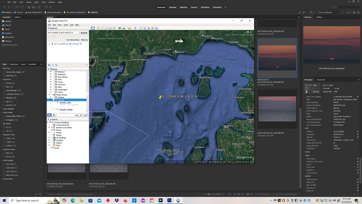
Adobe Bridge window and Google Earth Pro window. Click the image for a larger version.
It started today when I was using Adobe Bridge to go through some sunset photos I had taken out my car window on a recent trip to Michigan. I wanted to know where I was at when I created these images. (I knew approximately where I was but not exactly.) Finding a photo location is usually a quick and simple procedure. My Canon 7D Mark II records the GPS coordinates of the images I take. I clicked on one of the sunset images in Adobe Bridge. Then I opened Google Earth Pro and placed it on top of the Adobe Bridge window.

Adobe Bridge closeup.
On the right side of Adobe Bridge I scrolled down the Metadata panel until I got to the GPS coordinates for the photo I had selected.
Adobe Bridge and Google Earth Pro closeup.
I took the latitude and longitude coordinates from Adobe Bridge and typed them into the search box of Google Earth Pro. Then I clicked the Search button to the right of the search box.

Google Earth Pro search result. Click the image to see a larger version.
Google Earth Pro dropped a yellow pin at my photo location. You can see it way out in Lake Michigan.
“Houston, we have a problem.” So far as I know, my car is not equipped to sail across Lake Michigan. Something is amiss. I checked the GPS coordinates for the rest of my sunset photos and they are the same. I know I was not out in Lake Michigan. What went wrong?
I was driving north through Michigan’s Tunnel of Trees, somewhere between Harbor Springs and Cross Village. There are places you can see Lake Michigan and places you can’t. I came to a clearing where I could see the sun just as it was disappearing into the lake. I grabbed my camera and telephoto lens and took pictures until the sun was gone. Two things probably kept the GPS unit in my camera from seeing enough GPS satellites to get a good fix on my location. First, I was in the car so the roof was a problem. Second, I was mostly surrounded by trees, again blocking satellite information. Based on limited satellite information, the GPS couldn’t get a good fix on my location. I am guessing my GPS picked up a satellite to the west of my location and came up with an approximate North-South latitude, which wasn’t too far off, but without information from more satellites, my GPS was way off on the East-West longitude.
If I wanted to get a better GPS fix, I could have gotten out of the car and walked toward a clearing that was closer to Lake Michigan so my camera could see more satellites, but time was of the essence. My total shooting time from the first photo to sunset was only 48 seconds.
So where was I really? I checked my trip log. When I am in the car I write down the time of each photo stop, the car odometer reading, a description, and the trip odometer reading.
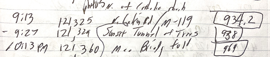
Trip Log
After taking pictures north of a Catholic church on N. Lamkin Road, I got back on M-119 (the Tunnel of Trees) at 9:13 pm. That intersection is at tiny Good Hart Michigan. As you can see, the car odometer was 121,325 miles and the trip odometer was 934.2 miles. My next entry shows I was done taking sunset photos at 9:27 pm. The odometers said 121,329 miles and 938 miles. They both show I was roughly 4 miles north of the intersection at Good Hart Michigan. That is not as exact as GPS coordinates, but that is better than, “I was somewhere on the Tunnel of Trees.”
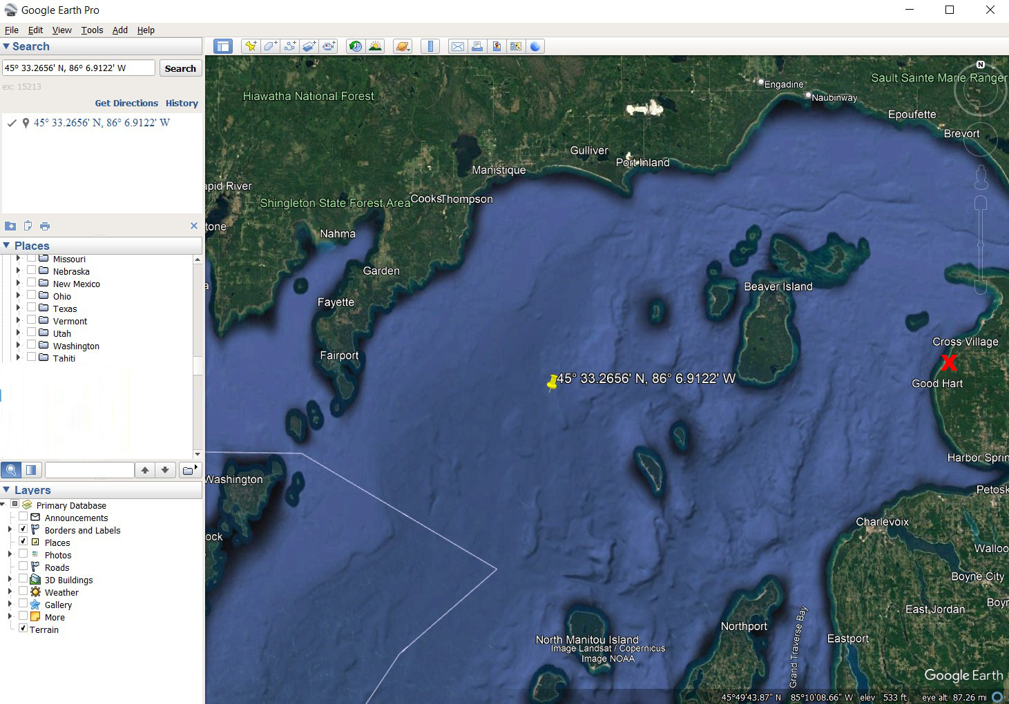
Red X: Sunset photo location on the Tunnel of Trees. Click the image to see a larger version.
I marked my approximate sunset photo location on this satellite map with a red X. I was about half way in between Good Hart and Cross Village.

Sunset, Lake Michigan, from the Tunnel of Trees about 4 miles north of Good Hart.
This is one of the sunset images.
FYI: The Tunnel of Trees is one of the prettiest drives in Michigan, especially in the fall.
My Links
“How To” Series: Using GPS in Photography
Other Links
16 Stops on the Tunnel of Trees at Michigan.org.
A Guide to the Tunnel of Trees at MyNorth.com